Vaudeville = Fabulous Public History

Collection homepage for "American Variety Stage: Vaudeville and Popular Entertainment, 1870-1920"
I stumbled across this website about 6 months ago when I was looking for information on the history of the entertainment industry. I find myself going back to it every now and then and just wandering around, there are so many great media pieces to stumble upon. The Library of Congress (LoC) created what is now their “American Memory” collection in the early 1990’s (1990-1994 as they experimented with digitizing their collections). It involves sound recording, prints, scripts, photos and moving images– what they call “the nations memory.” This collection is huge, over 9 million individual pieces kind of huge. For this project, I specifically looked at “American Variety and Stage: Vaudeville and Popular Entertainment, 1870-1920.”
Harry Houdini to the left of Theodore Roosevelt.

As someone who believes that the evolution of entertainment and show business mirrors the evolution of American culture and values, this project was made for me. Although I’d like to think the LoC had the foresight and desire to spend all that time for just me, I’m sure their intended audience was much broader. They wanted to make these resources available to the American public, and anyone who was interested in the subject- both scholars and the layperson alike. I think accessibility is a direct result of their learning objectives: open the door for a better understanding of the history of show business and show how entertainment during this period tried to deal with hot topics (race, gender, ethnic stereotypes). Secondarily, it puts history in the users hands (or at their mouse) and to shows what American society one did during their leisure time.

Richard Nixon and Elvis Presley in the Oval Office.

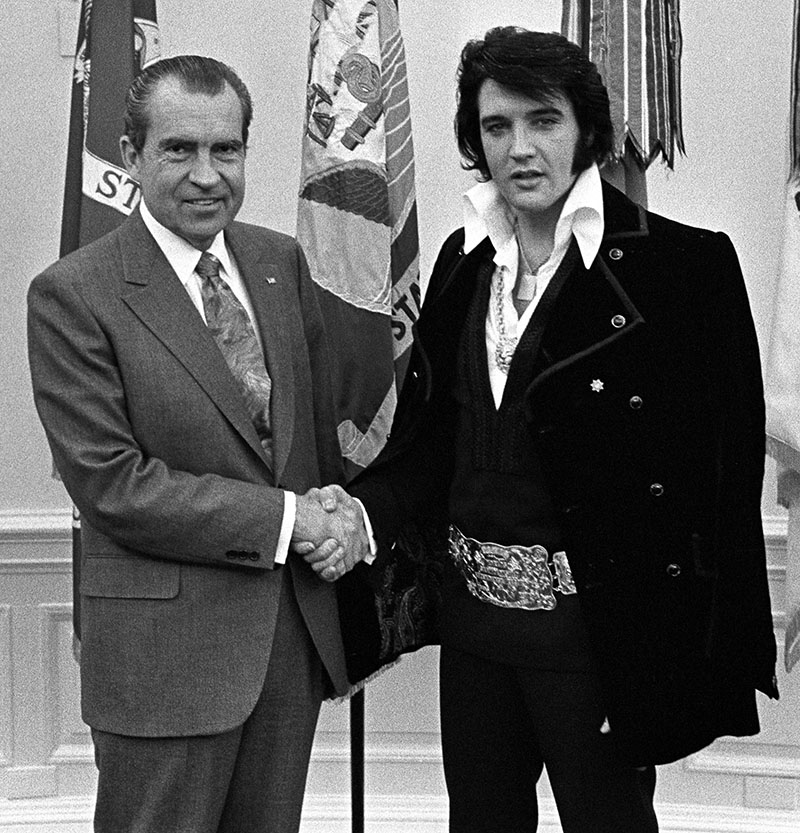
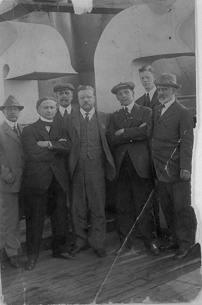
I enjoy this collection not only because of the subject matter, but because you can listen to .wav clips of some really fun old recordings. They highlight a handful of recordings from Vaudeville-era performers demonstrating comedy routines, music and poetry readings in styles that were popular at the time. For anyone who is interested in cultural history of Gilded Age to the Roaring Twenties will easily find a way to amuse themselves with this particular collection. I found this photograph of Houdini and Teddy Roosevelt together and couldn’t help but also think of the Nixon/Elvis picture taken decades later. Rock stars of their given generations! Losing yourself in rabbit holes is about the extent of the interaction of this particular site, though. There wasn’t much public feedback into the design that I could tell, but there are links to show how to use the collection, ask questions, etc., so it seems like the LoC welcomes interaction in that way.

This is a public history project that, with some scaling, could really highlight aspects of Idaho history. Digitizing collections is a time consuming process, but the end result is a product that the public can use in quite a few different ways. While it isn’t as sexy as some other public history projects out there, it is a project that’s easy to maneuver. If I was to use this as a template, I would be sure to add a little more interpretation. There are essays that, if they are read, are full of good information, but I would guess most people wouldn’t be interested in reading that much. Paragraphs that give a good explanation  for those who want something short, while fostering interest and telling where to find more information if they are interested would be much more useful.  What I like most about this site is that it presents history as more than a timeline or regurgitated facts. The collection can offer a new way to think about what was going on in society at a certian time and act as a completly different kind of primary source. 

Sources:

“American Memory” from the Library of Congress, http://memory.loc.gov/ammem/index.html

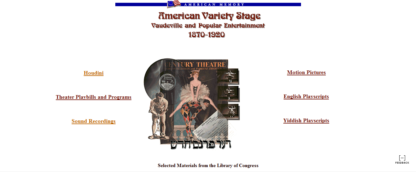
“American Variety Stage: Vaudeville and Popular Entertainment, 1870-1920,” http://memory.loc.gov/ammem/index.html

Photograph of Theordore Roosevelt and Harry Houdini, Library of Congress, http://memory.loc.gov/cgi-bin/query/D?varstg:98:./temp/~ammem_g6xk::

Photograph of Richard Nixon and Elvis Presley, National Archives, http://www.archives.gov/publications/prologue/2004/winter/images/nixon-elvis.jpg

Boise Architecture Project

Boise Architecture Project

The Boise Architecture Project is an on-line gallery of historic buildings in Boise and some of the surrounding area.

http://boisearchitecture.org/index.php

The project was started in 2005 by a group of students from the AP U.S. history and photography classes at Timberline High and the AP Geography class from Capital High. The group was inspired by the variety of interesting architecture in Boise. The group’s members went around the city and picked out their individual favorite building. They then researched the historical and architectural backgrounds of the building through interviews with building owners, architects, occupants, Boise preservationists and historical research. Once they had this information, they put pictures of the buildings and the information together to form a “slide” for each building.
The intended audience for the project is the community of Boise. It is also helpful to both historians, which is how I came across it, and residents who could not only look up community properties but possibly research the historic background of their own home. The project is designed to allow residents to actively participate in the project’s creation and expansion. Students created the entire project with help from the community. Residents can look up buildings by part of city, name, description, and architectural style. Community members can also add their own recommendations for new buildings to be added to the database simply by filling out a form on their website.
Though not directly stated, I believe the main objective of the project is to get people to see and care about the architectural diversity in Boise. The creators want everyone to begin to look around and analyze the buildings around them to discover their own favorite buildings. I think of it as the on-line version of the walk we took during the last class where we just walked around the North End and took in what we saw. This project could easily be converted to an app.
The project is definitely replicable. It is easy to do and only requires some leg work and interviews. I think it would be an easy project that people can work on and could inspire a lot of community members to get involved because it is so easy. I would love to see it expand to other cities in the area, such as Kuna or Caldwell. There are a lot of historic buildings in Caldwell and I think a project of this type would fit in well with that city’s plan for “renewal.” This type of project would be a good starting point for any city that wants to start documenting its history.
I think the project would be very helpful to public history projects in Boise because not only is the format of the project easily replicable, the content is easy to produce with community photos and information. I came across the project when I was beginning my research on the (Y)WCA in Boise and it helped me have a starting place for understanding the building. I then spent time looking at all of the other buildings and was surprised by the quantity of cool buildings in all areas of town.

http://dohistory.org/home.html

If you have ever heard the phrase “Well-behaved women seldom make history” then you have heard the words of Laurel Thatcher Ulrich. Often the saying is used to encourage misbehavior from women. For Ulrich, it meant that we need to search for the silent figures that do not always make history headlines. Ulrich wrote a popular book A Midwife’s Tale. In her book she follows the diary of a midwife, Martha Ballard, in Maine. Her book is written using several primary sources. The most important primary source she used was the diary of Martha Ballard. In my final semester as an undergrad student, Ulrich spoke to a class of students about the importance of primary sources. The website DoHistory encourages the public to engage with primary sources. The website is created by Film Study Center, Harvard University and hosted by Center for History and New Media, George Mason University. Ulrich is currently a professor at Harvard.

DoHistory reaches out to several interests. They focus on seven areas that connect to the Martha Ballard’s diary. These areas are: Martha Ballard, genealogy, how to use primary sources, midwifery and herbal medicine, teaching with this website, diaries, and films about the past. The project’s objective is stated in the “about the site” http://dohistory.org/about/site.html.

The website is intended to be an example of how to piece history together. They use Martha Ballard as case study. The website gives access to Ballard’s diary in two ways. It show the diary transcribed and in its original form. This section of the website http://dohistory.org/diary/index.html allows the user to “Explore the Diary” or “Practice reading the Diary.” The main page of the website gives full access to the Ulrich’s book and the PBS film made after Ulrich’s book. The “Archive of Primary Documents” gives examples of the ample primary sources that are available for study. The “Doing History” link shows a model of how to compare and contrast primary documents. The “On Your Own” link http://dohistory.org/on_your_own/index.html

gives helpful resources to move forward with your own research projects. The “On Your Own” link illustrates the websites purpose, to promote the user to research other primary documents in history, particularly, to do “research on other “ordinary” people from the past.”

 The project is a small cross section of history. The project size is ideal. It is not overwhelming for a new researcher to grasp and gives a variety of ideas on how to work with history. I would not add more to the case study because the expansion could lose the purpose of the project. In all aspects of this website it links to the use of primary documents. If the website were to add, for example, how to use secondary sources it would lose the emphasis on primary sources. The project could be replicated for a secondary source use. A website could be created that mirrored the use of secondary sources with a case study. Creating second website would allow for the purpose of both websites having independent thesis statements.

The participation on the website ranges from general interest to being taught at college level courses. This is shown in the seven categories. It gives teaching helps and reaches to specific interests, such as, midwifery. The intended use of the public for this project is specific to the seven categories listed for interests. The website does try to develop several angles in which a person would be able to find interest in the topic. For example, if you are not interested in midwifery, perhaps your interest is genealogy.  The same case study can be used to educate the user on how to piece history together. The set up of the website could be used for a Boise public history project. A case study that could be used for Idaho is the Idaho’s “Trial of the Century,” in which, Clarence Darrow came to Idaho as defense attorney for the trail for the assassination of former governor Steuneburg. The interest of the public would be exact from the do history website, such as, use of primary documents, films about the past, teaching with this website, and Clarence Darrow. Other connection would be trials for assassinations, law, and early Idaho history. Unlike websites that just provide the information about the topic, DoHistory encourages critical thinking about the topic. Doing history of for the Idaho case could have the user demine their verdict to the case given primary documents available via the website.

The website is a creative tool that can be used in a classroom level. With Idaho’s new focus on “technology in the classroom.” Websites like this are helpful to encourage students to find the answer rather than being given the answer, memorize it, and write it down on a test. Adding blogs to the website for the public and student use could add an additional interactive level the website.

Exploring Public History Apps

I think the post titled “But I Want You to Think!” by Jeremy Boggs is an excellent starting point when thinking about our mobile public history projects. Often academics can get caught up in the “informational” aspect of a project, but with any public history project the historian needs to keep their audience in mind first and foremost, and think about what degree to which the audience will be involved.

With Sarah Kessler’s “7 Ways Mobile Apps are Enriching Historical Tourism,” I took the next step in thinking about the app project and looked at a few examples of mobile apps created for historic sites and museums. It is interesting how these applications capitalize on aspects of a city or area that will be most engaging for tourists or those using the apps (i.e. Chicago’s mobsters, Hollywood’s Walk of Fame, murders and crime, etc.) I think it is going to be important to start small when building these apps, focusing on one aspect rather than trying to cover all of Boise. With any luck it could grow into something on the scale of the London Time Travel Explorer app. In the case of the Walk of Fame, which is such a large and meandering tourist attraction, a mobile app seems necessary to have when visiting.

From the “Augmenting Archaeology” article I went on to check out “The Civil War Augmented Reality Project” at http://acwarproject.wordpress.com/. I love this project because the creators have taken a strong interest in making the app truly interactive. While we’ve seen quite a few augmented reality apps, this one places an emphasis on stories, people and allowing the reader to choose their path in the app itself. While we can hope to add another dimension to historic places in our apps via pictures, audio, etc., this app takes it a step further and uses that information as a starting point for interactive stories behind the sites.

When asked during class the first week to think about public history projects, the first thing that came to my mind was, of course, interpretive signage. While that can still be very effective, looking at what historians are trying to do through these mobile apps should inspire everyone to think about the possibilities the public history field holds.

What the user wants

I had fun playing around and reading all of the blogs in our homework this week, and getting to tell my husband that I was actually doing my homework playing with apps. Our first assignment about “But I want you to think,” was a nice piece to frame the whole discussion of using the Internet and multimedia projects as a fun way to learn. It showed that public history projects tow the line of what the user wants/needs, and what we think the information and services should be. The reading about the 7 apps enriching cultural tourism really reinforced this point, because it shows if you can create something that the user wants, you have their interest long enough for them to learn something (if that is your goal).

The only reading I found dissappointing, from my history background, was the “Haunts: Place, Play, and Trauma,”  because of the fact that they were encouraging made up stories of places. This only makes me uncomfortable because the audience should know whether or not they are reading fiction, even if in some ways history is as made-up as fiction. From a user stand-point and a creative writing background, I loved this idea. So the fact that I didn’t like it was because of the internal battle that ensued.

To end this discussion of balancing what the user wants/needs, I think we need to make it fun, no matter what. That is probably why entering games into the mix of learning history is so appealing: it’s not dull or dry at all. The video “Too late to Apologize” brought this home; it was fun to watch, and I can’t help but have taken away iconic images/information, like the prases from the Declaration of Independence. I will also never forget the violin solo, and the rockin’ forefathers.

Nazis, Covanent, Reapers, Terrorists, Oh my…

If I had known video games could be brought within the fold of public history I would have entered the applied history program rather than the MA track. What makes video games valuable purveyors of cultural heritages/landscapes is their use of what might be termed the new social history paradigm. All of the games allude to above utilize what might be called a ‘bottom up’ approach to their gameplay narratives. In Medal of Honor the player goes through the game as a low-ranking enlisted man butchering nazis in WWII senarios like D-day (although in the newest Medal of Honor you play as either a US special ops soldier or as a terrorist).

In Halo the action shifts away from the earth’s past to an imagined community in the future. The player progresses through the game as the ‘master chief (he is so bottom up he doesn’t actually have a name),’ but can also play as the arbiter-a covanent elite. In Mass Effect the player goes through the game as commander sheperd, another fairly nondescript. The games cultural landscape is once again set in earths future as it is being attached by a race of alien machines known as the reapers. The game is quite pc and commander sheperd can be whatever race of gender the players whims dictate. Mass Effect also offers a valuabe lessen in multiculturalism as the player is part of a multi-species party.

Ultimately games offer players a valuable experience frolicking through imagined historical heritages. Games such as Mass Effect actually allow the player to make normative ethical choices that affect the games narrative. Unlike other forms of public history games are also very interactive. This makes them ideal as a platform to reach the public. Some types of games would be better than others at emmersing the player in cultural landscapes. Games such as the new Sims, which takes place in Medieval Europe, are ideal for exposing unsuspecting players to history. The day might soon dawn when the most important and influential public historians are programers.

Ensign Valve

Many years before my family moved to Boise, Idaho I had an interest in Arrowrock Dam. My grandmother gave me this “antique” picture postcard for my postcard collection. The card had been sent to her father in Iowa in 1922 from family friends who were visiting Idaho.


Arrowrock Dam is just over 20 miles from the City of Boise upstream on the Boise River.  It was considered a rather fantastic engineering project of the time (1911-1915). It is only within the last decade that the several miles of road from Highway 21 up to the dam were paved.  I’ve experienced the drive many times when it seemed too narrow, curvy and slow and the surface was often either hard-packed, washboardy dirt or mud. It amazes me that before more modern vehicles were in use it was such a popular tourist destination.

It’s not the dam itself that I want to tell you about. Around 2003 some work was done on the dam to update the valves used to control the flow of water. The old ensign valves were taken out and replaced by a newer type called a clamshell. One of the huge, rusty ensign valves was saved and is now on “display” near the dam. The valve is mounted so it can be viewed from all sides.  The Bureau of Reclamation of the Department of the Interior had a large sign made with lots of information about the function and operation of the valves, how they were developed and where they were located on the dam structure.


I don’t question that the Bureau of Reclamation chose to preserve this piece of old technology for the public to view and learn about. I question where they chose to put it and whether or not it is really being preserved.  Before one reaches the dam there is one of the familiar brown historical markers we see all over the state telling about Arrowrock Dam. There is space to pull off safely and read the marker and view the dam from a distance.

 That seemed a likely place to put the valve, but that’s not where the valve is displayed. For people who just make the trip that far and don’t want to travel past the pavement, they will never know about or see see the valve display.

The road makes a long, unpaved switchback at the front of the dam. Then as it passes the dam it goes through a blasted out rock archway and continues beside steep rock face on one side and a steep slope down to water on the other. Many vehicles with boats and trailers in tow navigate this precarious section of the road in summer and winter to get to recreation areas behind the dam. A fairly large turnout was created to help with traffic flow. It is in that turnout that you will find the valve.


As I see it the display’s best function is to provide something to look at while using the turnout to let faster moving traffic pass. In the “not so useful” category:


  • It takes up space in the turnout that vehicles use and need for safety.
  • It’s a distraction from driving on a section of road that requires attention.
  • Anything interesting and not in full sight placed along that road is subject to graffiti and is likely to become a target for gun shot. (The sign already has spray paint on it.)
  • The wire rope surrounding the valve does not discourage or prevent people from climbing all over it.
  • If a better idea for preserving it ever came about, its size, weight, and present mounting might be prohibitive in moving it elsewhere. 

How the Boise River water flow is regulated and how our fantastic irrigation system was developed and continues to be maintained have helped Boise to exist and grow. Remembering and preserving a piece of the technology that helped that system for almost 100 years seems important. The choices made for the ensign valve display seem thoughtless.

That’s so homestead…

It is my pleasure to introduce you to the Moon-Randolph Homestead. The property itself is located a mere 2 miles from downtown Missoula, Montana and stretches 170 acres. The history behind the property dates back to 1889 when the Moon family originally homesteaded the land. Over the last hundred plus years the land passed to various family members and has been home to cattle, chickens, hogs, cherry and apple trees, and various vegetables. The City of Missoula purchased the Moon-Randolph property in 1996 to preserve the open space for plants, animals and people alike.

In 1998 the North Missoula Community Development Corporation (NMCDC) embarked on a mission to save the northwest corner of the homestead, the location that encompassed the buildings that had been built or maintained by the Moon and Randolph families. The campaign to preserve the homestead was successful and in 2000 the NMCDC and the City of Missoula Parks and Recreation have managed the property through a cooperative agreement.

Today visitors, senior citizens to elementary children on field trips are able to experience the Moon-Randolph Homestead and find out what it was like to live the pioneer life. This is not thanks to an employee who has a 9am-5pm shift. It is thanks to the Smetankas family; who live on and care for the homestead. A Sunset Magazine article explains, “In exchange for living rent-free in a converted chicken coop, the Smetankas care for the land and livestock; maintain the buildings, including the original 1889 Moon cabin; coordinate a Maypole party and harvest festival; and greet visitors every summer Saturday.” This is all in addition to their day jobs. Andy Smetankas is a free-lance writer and teaches in Missoula and Joanna Smetankas co-owns a children’s clothing store also in town. Speaking of children, did I mention they have two boys Asa and Axel?

Per the Smetankas’s agreement with the NMCDC while living on the homestead they are to “value the homestead as a cultural landscape where active stewardship co-exists with layers of human and natural history.” However, they go above and beyond this and share with everyone who has access to the Internet as they blog (Moon-Randolph Homestead Blog) and create YouTube videos of their experiences while living on the homestead. While they have electricity and a computer, the modern amenities stop about there. The whole family shares a “family bedroom” and there is no modern plumbing.

Sun Before Arises–Moon-Randolph Homestead YouTube Video

The Moon-Randolph Homestead has even inspired a new take on language for the Smetankas. Joanna explains on her blog “We’ve been using the word ‘homestead’ as an adjective for a long time. Whenever we do something really hard-core or over-the-top pioneerish, we say something like ‘Damn, baby, that’s so homestead of you.” Their Top 10 hard-core moments include Andy smoking out a skunk near the chicken coop/house and Joanna squatting to pee into a chamber pot at nine months pregnant—“like, thirty times a day.”

While the Smetankas family live life rustically, they don’t do it alone. Come spring they enlist countless numbers of more than willing volunteers to help them plant gardens, take care of livestock, and maintain buildings. All the while these volunteers and visitors who come on summer Saturdays get to interact with the history, culture, and environment of the Montana landscape. The public is an essential piece to the sustainability of the Moon-Randolph Homestead. Not only do they visit and volunteer, private donations from the public are the homestead’s lifeblood.

The Moon-Randolph Homestead serves as an example of what can be done in the Inter-Mountain West in persevering the quickly depleting pre-Great Depression agricultural landscape. The way in which people once lived is becoming something one reads in a textbook rather than something you experience first hand. The Moon-Randolph Homestead is an excellent model of what could be done in Boise with the Pearl Jensen Farm Property off of Lake Hazel Road. Not only could it serve as a symbol of the pioneering spirit of Boise’s past, but by embracing current technology like blogging, social media, and mobile applications it can cement its place in the future. Who knows, you could even start uttering, “Damn, baby, that’s so homestead of you.”

Sources:

Moon-Randolph Homestead Blog

http://www.nmcdc.org/mrhhome.html

http://www.sunset.com/home/pioneer-living-in-montana-00418000068933/

http://www.facebook.com/pages/Moon-Randolph-Homestead/374267928824

Fabulous Public History via Augmented Reality

It is difficult to summarize a project that is used in so many different ways by different groups of people, and developed for different groups of people.  Augmented Reality is one of the most intriguing things about virtual-anything.  There is no limit to its uses, whether it be for a card company, i.e. Hallmark creating their e-card you have to hold up to a webcam to see the picture, the AR analyzer that allows you to analyze which size box you will need to ship your item with the Postal Service, or a car company using the technology to improve on, or innovate, a design; though my personal favorite is the Ray-Ban virtual mirror.

Postal Service AR

With so many companies using the augmented reality design, it is somewhat difficult to pinpoint the creator of the tool, though I would name Apple as the responsible party at this point.  There are several AR apps on virtually all smart phones, yet the first to have the historical significance was the iPhone.  Using this application can not only take you on a tour of historic places near where you are, or tell you where to go if you are vacationing somewhere, but can show you what was there one hundred years ago based on GPS technology.  The term “time-traveling tourism” is quite the proper term for this, in my opinion. The idea of time-travel is interesting to a large percentage of people around the world; it’s why Star Trek, Star Wars, and movies like Back to the Future are so popular.  Everyone wishes they could hop in the DeLorean and see what it was like back when.  Unfortunately, until Doc Brown reveals his secrets of creating a flux capacitor, we will have to rely on augmented reality and the years of history—photos, stories, and actors—that are used and involved in the process of making an application such as this.

The learning objectives of the application vary based on which company uses it, but for the most part, the smart phone applications use AR for historic purposes.  Or virtual soccer.  Though it seems awfully dangerous to stare at your feet and kick around.  Many of the articles that we were assigned to read involved AR, and they were for the purpose of educating visitors, or even local people, on the history of the place they were.  The learning objective is to make the program fun and interesting to more than one group of people, with options of either audio, visual, or both to cater to the learning preference of the viewer.  In places such as the Louvre, they have a tour of the museum that is on a screen that brings up a tiny virtual host at each exhibit.  In cities such as London and New York, taking a picture in an application using AR can overlay a photo, and even a story, of that exact location long ago (storyteller lingo).  It really IS like time travel!


Bringing this project to Boise would not, in my opinion, be a difficult feat.  Challenging? Yes.  Time consuming? Oh my!  Worth it?  Most definitely.  With so many things around Boise that basically only historians and history buffs know about, having something so interactive and able to cater to a specific learning preference would be greatly beneficial.

In Your Face History

“In about 1910, a strapping, hard-drinking shepherd called Irish Dick traded a pet bear cub to a Toppenish saloon-keeper for whiskey. Some months later, the rowdy shepherd was in town when his grown-up pet escaped, panicking townsfolk. He offered to return the bear to its tether. A terrible fight on mainstreet ended when an unharmed bear was returned to saloon servitude and a brave and bloodied Irishman was taken to the hospital. The mural, painted by Bill Ross and Jan Sovak, is on the 88 Cents Store building at Washington and Toppenish Avenues.”

Paintings and murals serve many historical purposes.  They can capture a historical event, but also reveal the overall importance of certain historical narratives within the city or town that created them.  The amusing story of Irish Dick could be lost in an archive somewhere, instead it is celebrated and shared with everyone who passes this mural.  Toppenish, Washington houses a public history project that I find particularly fascinating.  Located within the Yakama Indian reservation, it is a town of about 9,000 people which houses 73 historical murals painted on the sides of buildings.  Toppenish launched it’s Mural-in-a-Day program on June 3, 1989 where 15 artists collaborated on one mural entitled “Clearing the Land” and completed it one day before and audience townspeople and tourists.  The festival (typically held the first weekend in June) draws over 1,000 people now and adds to Toppenish’s mural count.  The Toppenish Mural Society presides over this project which includes the Mural-in-a-Day activity and other murals painted by various artists throughout the town who like to spend more than a day.  The Toppenish Chamber of Commerce includes a mural map that has a description of the historical significance of each mural.  During the summer there are self-guided and wagon tours that showcase the murals.

The murals are intended to convey many things about Toppenish.  They celebrate their Western History with murals about rodeos and cowboys.  They honor their Native American history with images of the early battles and treaties between the Yakama Nation and settlers from the U.S.  The murals also feature influential townspeople throughout Toppenish’s history: Alex McCoy (first Indian judge) and Maud Bolin (first woman to jump from a plane with a parachute and famous rodeo star).  The culture and history of this small town are captured in a relatively small area that is easily accessible to almost anyone who passes through Toppenish.  The murals are not encumbered with lengthy or tedious signage making them enjoyable for the casual observer to have a taste and feel for what Toppenish asserts is its history.  For those who are intrigued about the stories in the murals or about the creation of the murals there are tours and pamphlets available to further interpret these paintings.  The Mural-in-a-Day activity invites tourism and encourages local townspeople to take an interest in a project created by mostly local artists.

I like the idea of including some murals in Boise and think that something similar to the murals in Toppenish could easily be achieved in Boise.  I have  encountered a couple of murals in alleyways in downtown Boise that I find fascinating and bring to mind several questions: when was it painted? what does it portray? why this particular building? how old is the building?  I also think that replicating the Mural-in-a-Day program in Boise would be a fun way to include the community in making decisions about what Boise’s history is and introduce public history in an engaging manner.  If Boise had several murals a walking or driving tour could be created to further interpret the mural’s historical content.

http://www.toppenish.net/toppenish/home.aspxhttp://www.toppenish.net/toppenish/home.aspx

http://www.visityakima.com/newsite/toppenish-washington.asp