As I looked through the different websites assigned this week I kept going back to the “Were you There.” I loved going through all the comments from people attending Elvis Pressley concerts or describing there experiences during the racially charged sixties. There was a part of me though that questioned the authenticity of the authors. I’m not sure how or if they verify the submitted stories. I’ll have to check into that further.
Month: February 2011
Fabulous Public History Project Introduction to Warren, Idaho
The early history of the territory that would become the present day state of Idaho was a history of those passing through on their way to another destination. Whether it was the fur trappers of the mountain man era passing through on their way to find rivers rich with beaver pelts or early settlers on their way through to the fertile valleys of the Oregon or California, Idaho wasn’t seen as a place to settle down. All that changed with the discovery of gold by E.D. Pierce in 1863 and along with the hordes of gold seekers, Idaho would have the distinction of being the only state in the union to be settled with a west to east migration!
Within a few short years after Pierce’s discovery, similar strikes were made in Florence, Warren and Idaho City along with discoveries in Centerville, Placerville and a hundred other boom to bust towns that make up Idaho’s mining history. And make no doubt about it, Idaho was settled and built by the mining industry. Soon after the discovery of these precious metals, came the industries and businesses needed to support them. Those thousands of miners needed food and supplies, lumber for building their saloons, shops and schools and plenty of whiskey and other “entertainment” to get them through the long, cold Idaho winters.
Fast forward almost 150 years and all that remains of those bustling boom towns are some dilapidated buildings, a few mine tailings and a scattered history of a bygone era. Those towns that sprouted out of the forests, sagebrush and river valleys to supply the mines have grown up to be modern cities with few connections to their mining roots. Almost every one of those people strolling through the streets of Lewiston or shopping the stores in Boise have no idea that a little over 100 years ago the fortunes of both “towns” were tied directly to the mining regions they supplied.
There are many difficulties that arise when we start to discuss how best to share this rich history of Idaho’s mining industry with the public. Many are unaware of the location of these mining towns. With Idaho’s vast geography and extreme winters, most of the ghost towns of the mining era are difficult if not impossible to get to part of the year. Some are only accessible by four-wheel-drive or ATV vehicles. But the visuals of these ghost towns are necessary to fully understand the history of this era so the question becomes how do we overcome these difficulties and insure that the general public have access to our rich mining history?
My public history project will attempt to solve these problems and will hopefully shine the light on Idaho’s mining history. Because Idaho’s mining areas are scattered throughout Idaho, my project will combine all the attributes of an auto tour guide, walking guide, history guide, naturalist guide and recreational guide. With the thought that most people will be driving from Idaho’s major population centers, the first part will be an auto tour to the mining town. The second part will be a walking tour around the town. I will also include an optional ATV tour so that those with offroad machines can tour the surrounding area.
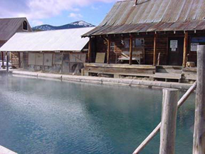
The current website that I found a while back and will be using as an example can be accessed through the links below. Although it is fairly simplistic and isn’t as polished as other websites, it contains the basic ingredients that I believe, when improved upon, will satisfy the needs of my project. It is an auto tour from McCall to the mining town of Warren, along with a walking tour of Warren itself. If you click on the link provided below you can seen that it includes information on mileage from McCall, natural resources of the area like Payette Lake, wildlife and their habitat and of course the history of the area. The website was completed by some locals who live part of the year in Warren. I believe it was created for other “locals” who live in and near Warren as well as for those who annually visit Warren. The people who created it love the area and wanted to share that love with others. I do believe it is replicable and plan to use this format and duplicate it for each mining town in the state. Below is a picture of the pool at Burgdorf Hot Springs which is on the way to Warren, along with some information provided.
Giza Pyramids – Fabulous Public History Project
A public history project that interests me and that would be user friendly to students at any grade level is the use of virtual tours. History instructors often teach and discuss geographic areas that students have never been to or even seen pictures of. What often interests students or sparks their interest in subjects is to see a graphic or photo of what they will be learning about. This also relates to learners of all ages and may be beneficial to any public history project. We often spend a great deal of time on-line researching articles, journals, and websites that relate to our area of study. Teachers may often use the internet and a variety of sites to support their student’s learning. They may include web quests, virtual tours, and student research.
My project focused on the website: http://www.pbs.org/wgbh/nova/pyramid/explore/menkaure.html
It is a PBS/NOVA website about the Pyramids of Giza
The website allows users to explore the three pyramids of Giza as well as the Great Sphinx. The site is user friendly and easy to navigate. Users may click on either: Khufu, Khafre, or Menkaure to learn more about the three pyramids. There is also information about; the history of Giza, age of the pyramids, how they were built, hieroglyphs, a virtual tour, and an interview with Dr. Zahi Hawass, Director of the pyramids. Also, included are maps of the site, excavation information, and teacher resources for lesson plans.
The following link includes a short video of a fly by the pyramids:
http://www.pbs.org/wgbh/nova/pyramid/explore/flyby.html
The project was created by PBS as a learning tool for the public to learn more about the Giza pyramids and ancient Egyptians. The audience may include; teachers, students, and the public in general. The project’s learning objectives are to educate people about how the pyramids were built and why. The pyramids are the great resting places for the pharaoh’s of Egypt. The Nile was used to transport the supplies and building materials to construct the pyramids. The precise date of the pyramids is unknown, however, many estimate that the pyramid of Khufu was under construction around 3200 B.C.
The project is replicable, and may be used as a model for any other historic sites to organize their own site that includes: videos, virtual tours, and maps. The project could be used as a template for other projects that may include; museums, historic sites, and even walking tours.
The site interviewed several specialists in the fields of: archaeology, historians, and the Giza director, Dr. Zahi Hawass. There are also posted email responses from the excavators in response to questions posted by the public.
The simple act of creating a trail…
Public History isn’t exactly in the vocabulary of Bostonians. Though this may be surprising to those not fortunate enough to have been raised in the fair Commonwealth of Massachusetts, when you live day-in and day-out in a city-sized museum, giving a title to it seems arbitrary.
Since initial settlement of what is now known as Boston, it has been up to the individual citizens, politicians, and Bostonians of all walks of life to remember, preserve, and create history. Up until the middle of the 20th century, this was all done independently. All of the sites and relics of the history of our nation that happened to be within the city limits were independent of each other, linked only by the story they told. This queued the interest of Bill Schofield in March 1951, and led him to establish one of the more iconic tourist destinations for the public.
Schofield became frustrated at the lack of publicity and accessibility of the historic sites in Boston, especially in being a local. In imagining the missed opportunities by tourists who may not even know what to look for, Schofield gathered his resources and made the first attempt of this venture in his very own medium; the newspaper in which he was a columnist. He called out to politicians, historians, site employees, and the common Bostonian to implement the idea which is now known as the ‘Freedom Trail’.
By June of the same year, Bill Schofield’s vision was realized as Mayor Hynes responded to his public outcry by stating that the city would be taking steps to establish, and begin development of the Freedom Trail. What began simply as signage and brochure guides has grown into a thriving public service that has paid limitless dividends to the city of Boston in tourism, economic growth, and publicity. For an already iconic city, the Freedom Trail gave the non-locals a way to fully immerse themselves in the history of Boston, and those events that played a vital role in the development of the Republic.
Today, the Freedom Trail sits subtly in the surroundings of a bustling city. What distinguishes the trail from the rest of the city is in the signage as well as the famous red paint and brick walkway that acts as a guide to the independent tourist (and their clever tagline, “So much history, we had to draw a line”).
One of the more popular aspects of the Freedom Trail is the “Walk Into History Tour”. This is where costumed guides will lead groups through various parts of the trail, or focusing on specific buildings or areas that are a part of the semi-official 16 sites. The Freedom Trail Foundation is the non-profit organization that runs and operates the trail in maintenance, tour development, and special events such as the African American Patriots tour that is now being advertised on their website.
Day in History – Costumed Guide
The beautiful thing about the Freedom Trail is that the entire idea is simple and universal, yet drastically changed the city and brought new light to venues that were at risk of losing their public relevance. As any Historian will confess, the public is the fuel that operates any history-based organization. If the public is not interested, or does not go to your museum or site, then public funding and support will disappear with it. The Freedom Trail brought new life to sites that were in danger of such a fate, and can serve as a model for any city.
While the title of the ‘Freedom Trail’ certainly wouldn’t tie in with Boise History, some other platforms could be considered. For the sake of argument, how about the ‘Chinese Path Through Boise’? A guided tour of the relics and former cultural areas of Boise. This could include the locations of China Town (now reduced to a single building, housing a laundry service), along with a tour of the Chinese Gardens (now known as Chinden Boulevard), concluding with an interpretive exhibit of the miners who initiated the wave of Chinese immigration into the Boise area. Just imagine – those binocular viewers that are spread throughout the city may actually get some use, and make sense!
The main theory behind this nerdy rant on the awesomeness (a grammatically correct, and perfectly descriptive adjective) of the Freedom Trail, is that if separate sites are suffering from a lack of interest or publicity opportunities, then the best bet is to combine forces. Although the sites still operate independently, the 16 locations on the Freedom Trail now experience a level of popularity that would have been nearly impossible had it not been for the vision of Bill Schofield and the continued efforts of the Freedom Trail Foundation.
Game Changer
“But I want you to think,” was life-changing for me. When I started at Boise State I did not waiver in my decision to do the M.A. over the M.A.H.R. degree because I have always wanted to research, teach, and reside firmly in the academic world. However, this class has been fascinating and eye-opening for me. I have always had a hard time committing myself to the idea that all knowledge is useful (who really needs to read a book about Lincoln’s doctor’s dog’s sex life? Brandie will at least get this inside joke.) Public history has helped me to focus more on what I think is important; which for me is the application and use of history. I think those in the public history field really grasp the importance of this and those in more of university-related history could improve their approach to presenting history by adopting some of the tenets of public history. I like the idea of considering what other people need or want to know about history rather than trying to fill a tiny, obscure niche.
I also loved the article on the “7 apps.” I wanted to visit these places just so that I could use these apps. They focused on interesting topics that would have broad appeal for many tourists. I also liked the slightly different take each app had of using historical maps or narrated explanations. Sometimes I think that technology can detract from an experience, but the apps in these articles only seemed to enhance an already interesting historical event.
Digitizing History
As historians entering the digital era we need to understand that the public demand is for quick, easy, and accessible information. Modern technology means that history projects can be delivered to our fingertips, but we must also keep in mind that it is a user-based demand. Users will be the ones bringing the latest apps to their friends, sharing the coolest new experiences through Facebook, Twitter, etc. We just have to deliver the experience, and if we succeed, the users will do all the work.
That being said, for this assignment I went back to a project that I discovered through a social media site maybe six months ago. “How to be a Retronaut” caught my attention, and I, in turn, shared it with family and friends on another social media site. http://www.howtobearetronaut.com/2010/03/ghosts-of-amsterdam/ . How to be a Retronaut is run by Chris Wild, who works as a historical consultant. It lacks an educational mission statement, but it is clear that he is aiming at topics that have an aesthetic and particularly visual appeal. I loved the idea of this semi-augmented reality, and wondered then, if it could work as an augmented reality app.
The Historypin (http://www.historypin.com/) is a website that has a similar approach to historical photos, but it is open to user-end interaction that the Retronaut project lacks. The goal of historypin is to bring people together through images, hoping that individuals will find some common ground through a sense of shared history. But it is not a guided tour, and has no projected ideas or points of discussion. Instead, the project paired with Google, using their street-view function that allows the user to wander through space and time, viewing augmented images at their leisure. Its scope is limitless as it allows users, urges them in fact, to contribute to the international collection of historical images. They make reference to the countless attics and boxes full of aging black and white photos that run the risk of being forgotten by a younger generation caught up in the daily delivery of digital media. It is an attempt to usher the old into the new, and to expose the young to the experiences of past generations.
In this way users are the ones building and guiding the project. This allows them to share their own history as well as explore that of others. For those of us who love to discover, it is a treasure trove. But the scope can be overwhelming, and I wonder if it might benefit from a little bit of guidance. With this approach users could create their own guided tours, perhaps build a historical cross-section of their own, via historypin. For example, my in-laws have established a detailed history of their family’s move out west beginning in Concord, Massachusetts in 1685. They have already documented their slow move westward, and have a collection of images from various settlements across the country. This type of guidance could enhance the historypin experience, and allow users to create their own place in history.
But that is just one possibility. Just one example of what is possible with this type of format. I would like to make some middle ground between these two projects, building a more guided approach, as well as one that is available, useful, and entertaining on the go.
Making Museum Apps Truly Interactive
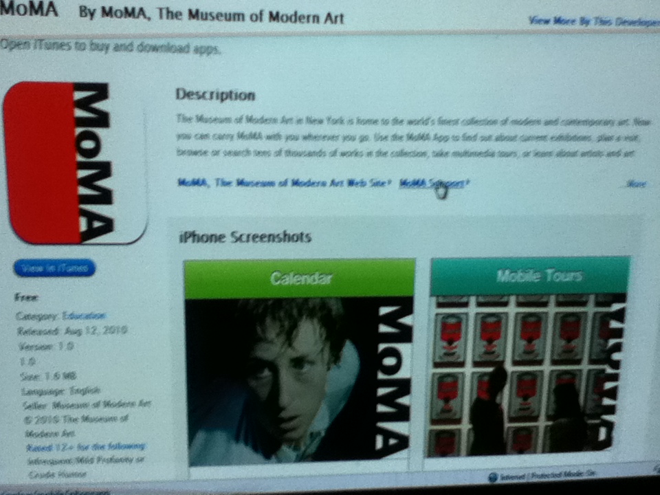
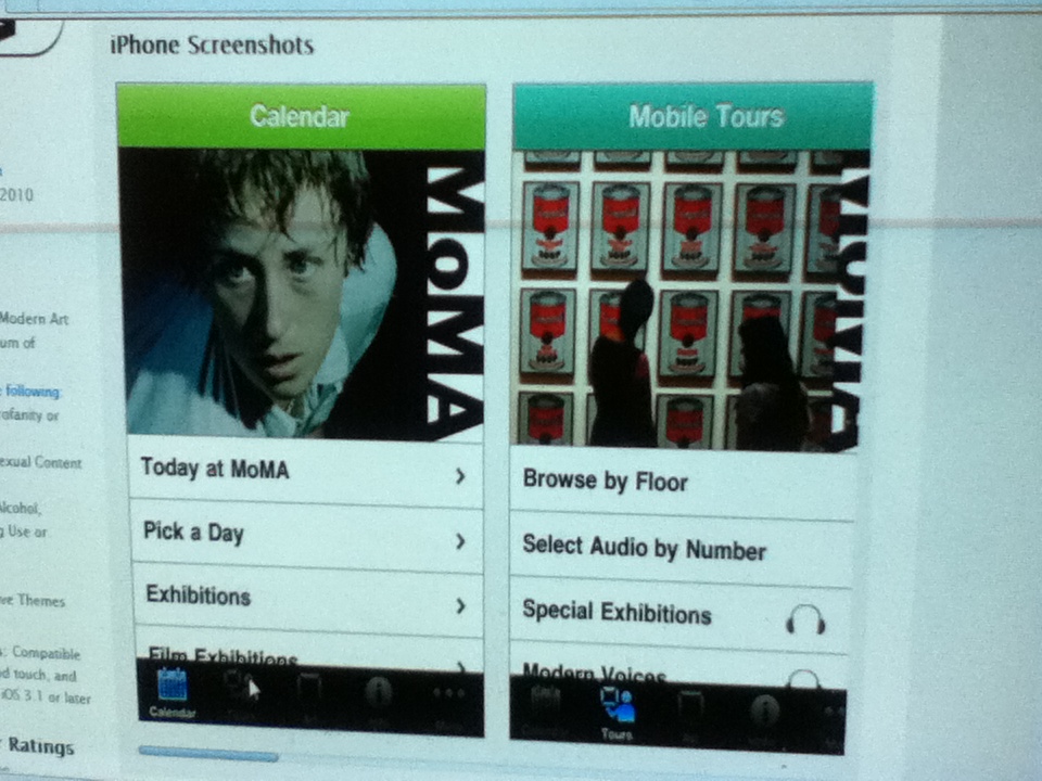
I wanted to choose a mobile application not discussed in one of our readings this week for my Fabulous Public History Project Introduction. The Museum of Modern Art (MoMA) in New York City has one of the best – a comprehensive application for its collections that can guide visitors through the museum and answer any questions they might have. The MoMA’s application includes several audio tour options which can be searched, not just taken as a whole. In addition, the app features the museum’s collection digitized for browsing the museum through your device, or learning more about the artifacts you see when visiting. This particular application sets itself apart from other similar applications by offering users additional information they might need when touring. It features a database of art terminology, as well as a calendar featuring all exhibit and event showtimes and screenings.
The project was created by the MoMA and released to iTunes as a free app on August 12, 2010. The project’s purpose seems to be the enhancement of the museum experience at the MoMA and to attract tourism. One of the application’s features is titled “MoMA Tracks.” MoMA Tracks provides guests with music options to accompany them when at the museum. This particular feature makes the intended audience of younger people and the tech savvy somewhat clear.
The learning objectives of this project go hand in hand with those of the museum. The Museum of Modern Art focuses on expanding artistic limits and showcasing newer aspects of art history, through historic figures such as Pablo Picasso. The MoMA places an emphasis on multimedia through its features on film history. They currently host an exhibit on German cinema between 1919 and 1933. The objectives of the application follow the museum’s lead by adding more substance and additional layers of information to their exhibits. The goal of the project is to provide guests with a personal aid or tour guide as they visit the museum.
While the application could certainly serve as a model for other museums to use when developing their own mobile applications, there is room for improvement within the MoMA app. The tours included are not the big draw for the application (that would be the index of works) as they are somewhat basic audio tours. I feel more aspects of the augmented reality applications we have seen could be added to make the experience more comprehensive. The project could definitely grow, but it does provide a good foundation for other museums to use. Despite the heavily interactive nature of the project (guests can choose a tour and music, etc.) audience participation does not truly factor into the design of the project itself, other than through user comments and reviews on iTunes.
This type of project would be ideal for multiple Idaho locations. Tourism in any place could benefit from mobile applications. An obvious idea would be to develop an application for the Idaho Historical Museum, the Old Idaho Penitentiary, or other area museums. Devices of this nature could be used for most historical points of interest in Idaho. Audio and photo tours for mobile devices, or augmented reality applications are viable options for the future of public history in Idaho.
Links:
The app on iTunes: http://itunes.apple.com/us/app/moma/id383990455?mt=8#
Official website for the MoMA: http://www.moma.org/explore/mobile/iphoneapp
“9 Free Mobile Apps for Exploring New York City” http://mashable.com/2010/09/07/new-york-city-apps/
PhilaPlace
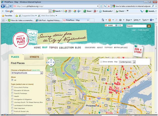
My fabulous public history project focused on the website, philaplace.org. The site is called “PhilaPlace: Sharing Stories from the City of Neighborhoods.” This project shows two maps: An image of historic Philadelphia, and underlying that one is a modern Google map. The project allows you to explore historic locations with photographs, stories, and place markers. A very nice interactive portion of this website is that it lets users contribute their own stories to the website. It also has a blog, and a collections tab that opens up over 1,000 photos.
This project was created by the Historical Society of Pennsylvania to feature Philadelphia neighborhoods, and allow people to contribute in order to connect “places through space and time.” They created the website for people to understand and interact with the history of Philadelphia, as well as document the changes that have occurred in the cityscape.
The project’s intended audience seems to be primarily the residents of the featured neighborhoods of Philadelphia. There seems to be room for improvement in this area to include travelers or potential travelers. A tourist could use the website, but by incorporating a couple of walking tours in certain areas or using location based apps the experience would be improved.
The learning objective of this website is much like our textbook, Everyday America; to read the cultural landscapes of Philadelphia and acknowledge the many experiences that have occurred in one place, even one building. One of the other objectives of this project is for the visitors to realize how each neighborhood, no matter how different they are, have played integral roles in the shaping of the city and the region.
This project is replicable, but I think an organization with enough resources would have to undertake it. One of the project pages mentions that several organizations partnered together and had at least two large grants. With technology becoming cheaper as they roll out new interfaces, cost might not be much of a deterrent for long because the cost is becoming more affordable. At the moment it is a great template for other projects. As for the PhilaPlace project as it exists now on the web, it can easily grow and have more content added to it.
Participation in the project by the public was an integral part to the project. It remains a part of the project still by allowing visitors to write their own stories down about places. Visitor comments are marked with a green thumbtack on the map, and comments from the Historical Society and other partners are also clearly marked. This is a very convenient part of the site because you can easily see who is interacting with it, and who is not. It seems as if not enough people have discovered it to share their memories about the places, or they are targeting the wrong age group.
I think this is a great project to bring to Boise, and with a couple of tweaks, it could become really prominent with social media and other avenues. By using social media, I think it would help encourage more engagement by the public. That seems to be one of the downsides of the PhilaPlace; not very many people outside of the historical society and their partners have shared stories. Perhaps a more vigorous media campaign would help that. If a similar project was undertaken in Boise, I think the addition of audio would be great. With audio, the group in charge of operating the site could gather anecdotal oral histories and upload them to the site too. I think this kind of project could become a nice balance of an educational and fun web experience, with both what users want and what historians think they want.
Thoughts
The point of applied historical research is to involve the public. Not only to involve the public, but to get them as excited about history as the historian. I agree with the article “But I want you to think” that all three parts, entice, inform and invoke are need to make a successful website. The part that I find difficult is how you entice your audience. Should we do “focus-group testing, user testing, and marketing”? That is difficult to for digital humanities and I dislike the idea of marketing the idea. History is not product to be sold. Using students a test group is an obvious answer, but the general public is more than students. How do we get them involved? The “7 Way Mobile Apps are Enriching Historical Tourism” helped me see what kind of mobile applications are already available to the general public. While informative on the applications, I would like to know how much use these applications get. Are they made and hardly used, are they used by tourists, students, or a local public? A study on who is using the already available applications would open up which ones need more work or what is working best for the user.
In creating an application available for historical information, the last thing I want is a tourist walking downtown staring at their Smartphone rather than engaging with the landscape around them. I am not sure I quite understand the augmented reality concept, but I understand that we take the user out the current landscape to engage another. I see the comparative value for the audience, but the augmented reality game takes away the “think for yourself” part for me. I also dislike the idea that there is just one alternate landscape, for example, the “Civil War Augmented Reality Project” that all you to look back via “pay binoculars” to see Civil War landscape. Could that landscape have been used for anything else since the Civil War? What happened to the landscape during reconstruction, the roaring twenties, or in the era of the greatest generation?
“Haunts: Place, Play, and Trauma” takes an interesting angle to getting the public involved in places and finding the secret information on spaces and letting the user add to it. But I have to ask the question that is posed in Gowalla article “ok, so what does any of the have to do with educations?” The ideas in the Gowalla article are excellent. I think museums lack interaction with the visitor. Creating applications that not only engages the visitor, but also encourages going to other museums. This is excellent. These could give a much needed revival to museums if provided to the public. It would “market” to younger audience.
For the Play the Past website, I think the idea is great. My favorite part is it allows for
“guest authors” encouraging users to not only engage with history via games, but add their thoughts to it. As for the youtube music video, I loved it! I posted it on my facebook. The comments on the video were intriguing, several high school age students posted their history teachers should them this and debate had been raised about slavery. I think the mask of a username on a website may allow for these high school students to voice their thoughts that they may otherwise be afraid to speak in class in front of their peers. There is no way I can prove they were high school students, but their arguments and answers mirror that of a textbook. So maybe they are listening in class. 😉
Vaudeville = Fabulous Public History
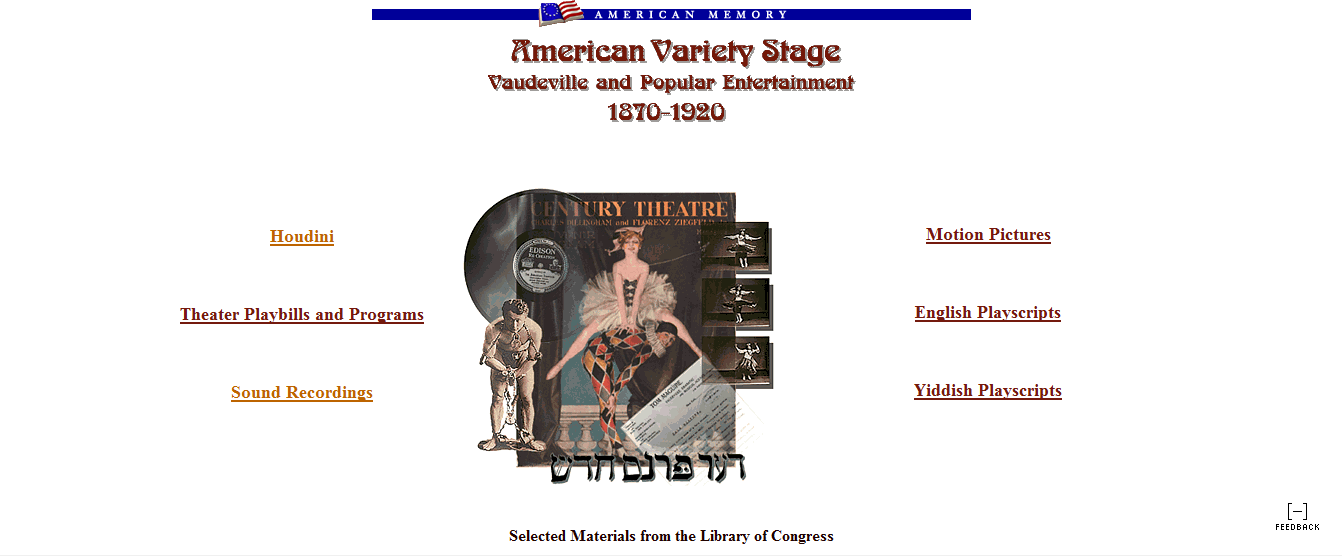
I stumbled across this website about 6 months ago when I was looking for information on the history of the entertainment industry. I find myself going back to it every now and then and just wandering around, there are so many great media pieces to stumble upon. The Library of Congress (LoC) created what is now their “American Memory” collection in the early 1990’s (1990-1994 as they experimented with digitizing their collections). It involves sound recording, prints, scripts, photos and moving images– what they call “the nations memory.” This collection is huge, over 9 million individual pieces kind of huge. For this project, I specifically looked at “American Variety and Stage: Vaudeville and Popular Entertainment, 1870-1920.”
As someone who believes that the evolution of entertainment and show business mirrors the evolution of American culture and values, this project was made for me. Although I’d like to think the LoC had the foresight and desire to spend all that time for just me, I’m sure their intended audience was much broader. They wanted to make these resources available to the American public, and anyone who was interested in the subject- both scholars and the layperson alike. I think accessibility is a direct result of their learning objectives: open the door for a better understanding of the history of show business and show how entertainment during this period tried to deal with hot topics (race, gender, ethnic stereotypes). Secondarily, it puts history in the users hands (or at their mouse) and to shows what American society one did during their leisure time.
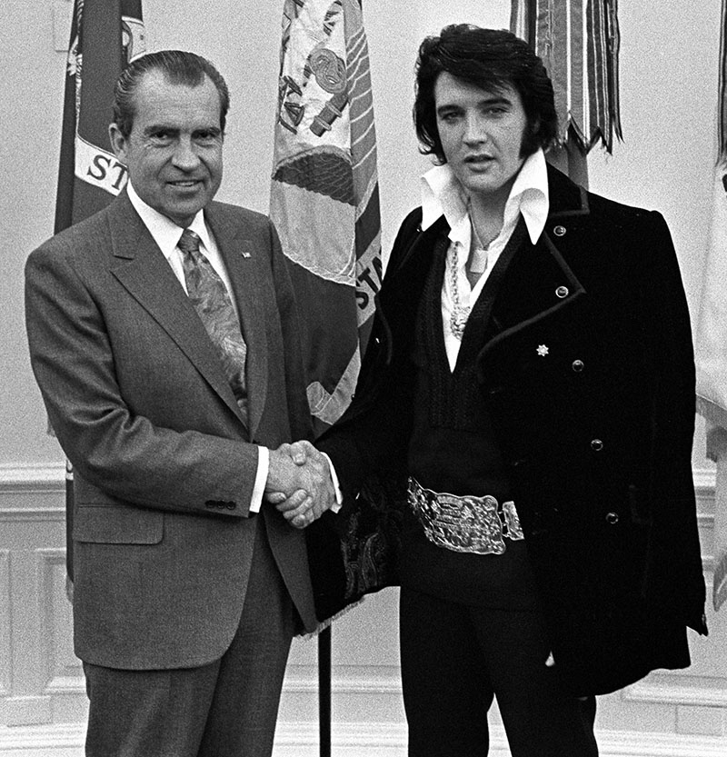
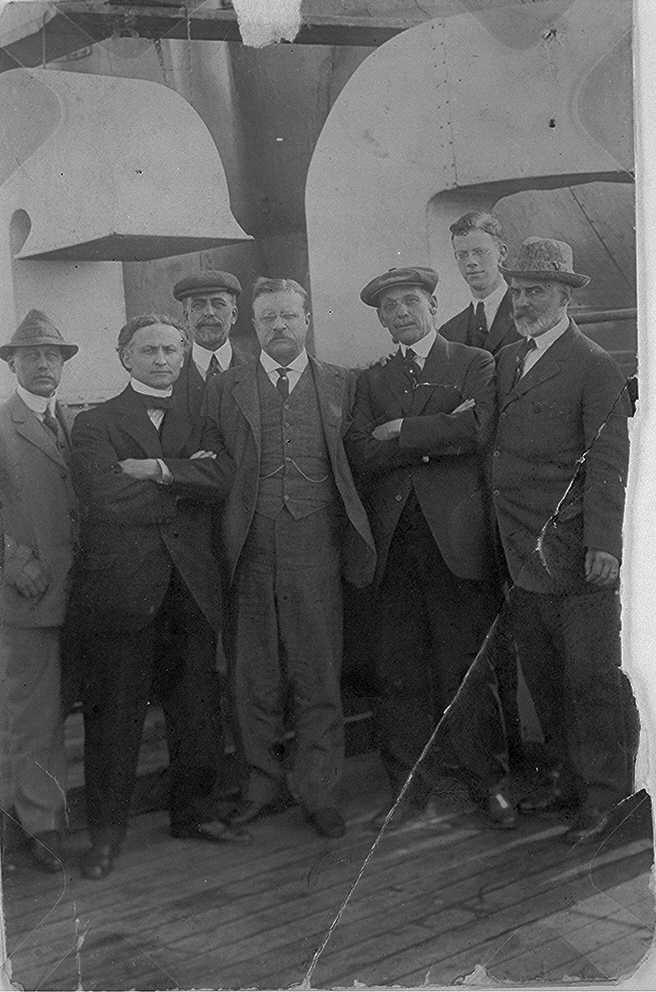
I enjoy this collection not only because of the subject matter, but because you can listen to .wav clips of some really fun old recordings. They highlight a handful of recordings from Vaudeville-era performers demonstrating comedy routines, music and poetry readings in styles that were popular at the time. For anyone who is interested in cultural history of Gilded Age to the Roaring Twenties will easily find a way to amuse themselves with this particular collection. I found this photograph of Houdini and Teddy Roosevelt together and couldn’t help but also think of the Nixon/Elvis picture taken decades later. Rock stars of their given generations! Losing yourself in rabbit holes is about the extent of the interaction of this particular site, though. There wasn’t much public feedback into the design that I could tell, but there are links to show how to use the collection, ask questions, etc., so it seems like the LoC welcomes interaction in that way.
This is a public history project that, with some scaling, could really highlight aspects of Idaho history. Digitizing collections is a time consuming process, but the end result is a product that the public can use in quite a few different ways. While it isn’t as sexy as some other public history projects out there, it is a project that’s easy to maneuver. If I was to use this as a template, I would be sure to add a little more interpretation. There are essays that, if they are read, are full of good information, but I would guess most people wouldn’t be interested in reading that much. Paragraphs that give a good explanation for those who want something short, while fostering interest and telling where to find more information if they are interested would be much more useful. What I like most about this site is that it presents history as more than a timeline or regurgitated facts. The collection can offer a new way to think about what was going on in society at a certian time and act as a completly different kind of primary source.
Sources:
“American Memory” from the Library of Congress, http://memory.loc.gov/ammem/index.html
“American Variety Stage: Vaudeville and Popular Entertainment, 1870-1920,” http://memory.loc.gov/ammem/index.html
Photograph of Theordore Roosevelt and Harry Houdini, Library of Congress, http://memory.loc.gov/cgi-bin/query/D?varstg:98:./temp/~ammem_g6xk::
Photograph of Richard Nixon and Elvis Presley, National Archives, http://www.archives.gov/publications/prologue/2004/winter/images/nixon-elvis.jpg